4

W Beach

W Beach https://ngatapuwae.govt.nz/w-beach If you look out to sea here, you can see the wrecks of the Allies’ ships – deliberately sunk to make piers. Ngā Tapuwae Trails /sites/default/files/stop/media/04%20cape%20helles%402x.jpg

If you look out to sea here, you can see the wrecks of the Allies’ ships – deliberately sunk to make piers. 


GALL_Zone4_Loc_WBeach_48k24bit_20150.mp3
Read this story

W Beach

You are standing at W Beach. This is the site of the second of the major landings by the 29th British Division on 25 April 1915. If you look out to sea, you can see the wrecks of the ships that were deliberately sunk to provide the piers to make this a logistic base. The landing here occurred in broad daylight, and the ship’s boats carrying the British infantry came in after naval artillery had pounded the high ground that you can see all around you.

Once again, Turkish infantry were in trenches on the high ground. They held their fire until the infantry got out of the boats and came up the beach to a barbed wire barrier, about where you are standing. As the soldiers tried to push through the barbed wire, they were shot down by Turkish fire.

Six Victoria Crosses were won here by the 1st Battalion of the Lancashire Fusiliers before breakfast on 25 April. Finally the brigade commander landed behind the cliff that you can see on your right and he and his soldiers attacked up the cliff and opened the way for his infantry to move inland. 

There was an opportunity from about lunchtime that day to push inland and provide support to V Beach – the next beach across. But that did not happen because so many of the officers and NCOs (non-commissioned officers) had been killed or wounded that they were leaderless, and no one took the initiative.
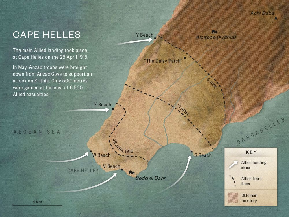
How to get here

Getting there

From V Beach return to the village square and turn left along the paved road heading west out of Seddülbahir. After one km you will see the stone column of the Empire Memorial on the left.

Continue past the turn for the road to the memorial and a further 500 metres you come to a gravel track on the left. Take this turn and drive roughly one km, till the track turns sharply to the left just after a small Ottoman era cemetery on the left hand side of the track.

Follow the track downwards 300 metres to W Beach.

Where to stand

Stand at W Beach and look out to sea.

GPS
40°3'5"N
26°10'1"E
Decimal GPS
40.05153
26.16718
  • Dugouts in the hillside, and stores stacked on the beach at Lancashire Landing (W Beach), Cape Helles 1915.
    Dugouts in the hillside, and stores stacked on the beach at Lancashire Landing (W Beach), Cape Helles 1915.Credits

    Australian War Memorial G00313 http://www.awm.gov.au/collection/G00313/

  • British troops hauling an ambulance wagon off W Beach.
    British troops hauling an ambulance wagon off W Beach.Credits

    © IWM HU 105649 http://www.iwm.org.uk/collections/item/object/205223073 

  • Soldiers of the Lancashire Fusiliers before disembarking at 'W' and 'V' beaches off Cape Helles on 5 May 1915.
    Soldiers of the Lancashire Fusiliers before disembarking at 'W' and 'V' beaches off Cape Helles on 5 May 1915.Credits

    © IWM Q 13219 http://www.iwm.org.uk/collections/item/object/205196079

  • The Mole at Lancashire Landing, W Beach, Cape Helles
    The Mole at Lancashire Landing, W Beach, Cape HellesCredits

    NAM 1992.1156.2 (2)

  • The first boatloads of men of 1st Battalion, Lancashire Fusiliers landing at W Beach
    The first boatloads of men of 1st Battalion, Lancashire Fusiliers landing at W BeachCredits

    © IWM Q 102538 http://www.iwm.org.uk/collections/item/object/205022810

Stories & Insights

The night before April 25, Freyberg made an epic swim around the coast – lighting flares to distract the Ottomans.

Soldiers graves, Shrapnel Gully

Public anguish and uncertainty grew in New Zealand, as official lists of Gallipoli casualties slowly appeared in newspapers.

British soldiers at Anzac Cove marching along North Beach.

While trans-Tasman relationships warmed at Gallipoli, new tensions emerged between the New Zealanders and the British.

The Bouvet was one of three Allied battleships sunk by mines during the naval attack on the 18th of March 1915

The Gallipoli campaign's land operations are well known, but Allied warships and submarines also played key roles.

Gasparich fought with the Auckland Battalion alongside the British at Krithia – coping with sparse and confusing orders.

Wounded being brought along side an unidentified hospital ship off Gallipoli. A good view of the barges and the lighter towing them. There look to be a number of walking sick and wounded as well as stretcher cases

Gallipoli was - in the end - just a very small part of the First World War story.

Leadley was a qualified telegraphist, so was given a signaller’s role when he enlisted.

Take the next trail

The next Ngā Tapuwae trail is The Defence. Proceed to Hill 60.
Link to the first stop

Decimal GPS:
40.14096
26.37536
Sequence:
1
Decimal GPS:
40.09741254106555
26.25176380859375
Sequence:
2
Decimal GPS:
40.04212
26.18528
Sequence:
3
Decimal GPS:
40.05153
26.16718
Sequence:
4
Decimal GPS:
40.08778
26.2149
Sequence:
5

Stop Images

Sequence:
1
Decimal GPS Real Location:
40.14096
26.37536
Sequence:
2
Decimal GPS Real Location:
40.09699
26.25241
Sequence:
3
Decimal GPS Real Location:
40.04212
26.18528
Sequence:
4
Decimal GPS Real Location:
40.05153
26.16718
Sequence:
5
Decimal GPS Real Location:
40.08778
26.2149