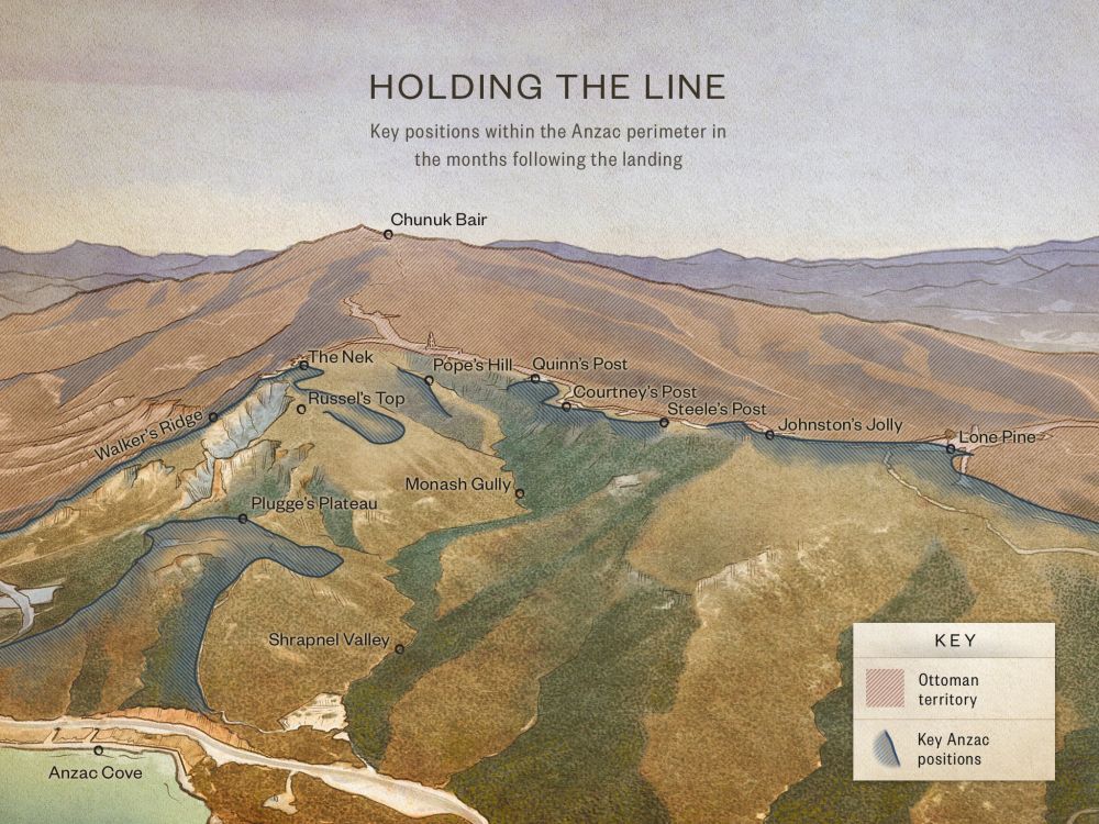
7

Russell’s Top

Russell’s Top https://ngatapuwae.govt.nz/russells-top Malone and the New Zealand Engineers consolidated this position as the campaign progressed. Ngā Tapuwae Trails /sites/default/files/stop/media/02%20holding%20the%20line%402x.jpg

Malone and the New Zealand Engineers consolidated this position as the campaign progressed.

GALL_Zone2_Loc_Walkers&RussellsTop_4.mp3
Read this story

Russell’s Top

On 25 April 1915, the Australians landed at 4.30 in the morning and made their way up here. Later that day, men from the Auckland and Canterbury Infantry Battalions followed them up and pushed inland. But on the evening of the 25 April they were driven back to where you now stand. This critical position was held by New Zealand machine gunners that first night. We know this because men from these battalions are buried nearby in Walker’s Ridge cemetery. The next day an Australian battalion occupied this position and came under heavy attack and was reinforced by the Wellington Infantry Battalion. 

Lieutenant-Colonel William Malone, commander of the Wellington Infantry Battalion, consolidated this position. Under Malone, the sappers of the New Zealand Engineers dug the trenches that you see here behind you. 

Later that month, Brigadier General Andrew Russell’s Mounted Rifles arrived as dismounted infantry and dug forwards to occupy the ground up as far as the Nek. 

And if you walk forward from here through the trench lines you will see the trenches developed by the New Zealand Mounteds during May and June 1915. 

The New Zealanders were still digging forward when, on 19 May, the Ottoman army mounted its big night counterattack. There was a gap between the unfinished trenches. As the Turks ran forward through this gap, the Anzacs mowed them down, the place was littered with hundreds of Turkish bodies.

At the end of the month they had an armistice to bury the dead, but burying most of them was impossible. All they could do was throw a light covering of earth over the dead. Any attempt to pick up the bodies that had been lying out in the hot sun for days saw the bodies simply disintegrate in their hands. 

The gully directly below you, which goes down to the beach, was known as Mule Gully, because it provided safe cover for the mules of the Indian Mounted Battery that was set up here on Walker’s Ridge and Russell’s Top. The mules brought supplies up the ridge. 

The New Zealanders thought that Mule Gully was quite exotic because if they went through the mule lines, there was a chance they would get a curry or a chapatti, and that was a great change from bully beef and biscuits.

How to get here

Getting there

WARNING: Many locations at Gallipoli are potentially dangerous, and there are undercut cliffs and sudden drops. Go slowly and carefully - and never stand close to a cliff's edge.

Leave The Nek Cemetery and walk along the dirt road that continues west.

Where to stand

Go past Walker's Ridge Cemetery on the right, and stand where you can see the sea in front of you and to your left on the coast Ari Burnu Cemetery. On your right you should see Walker's Ridge running down to the sea. On your left Russell's Top extends towards the top of the Sphinx.

GPS
40°14'28"N
2617'17"E
Decimal GPS
40.24133
26.28818
  • Communications trenches at the rear of the Russell's Top position.
    Communications trenches at the rear of the Russell's Top position.Credits

    National Army Museum 1992.742 http://nam.recollect.co.nz/nodes/view/4225

  • Wellington Terrace with dugouts. Walker's Ridge is on the top left hand corner. 
    Wellington Terrace with dugouts. Walker's Ridge is on the top left hand corner. Credits

    Wellington Terrace with dugouts, Gallipoli, Turkey. Read, J C :Images of the Gallipoli campaign. Ref: 1/4-058075-F. Alexander Turnbull Library, Wellington, New Zealand.http://natlib.govt.nz/records/22766985

  • A soldier of the Patan Mule Corps.
    A soldier of the Patan Mule Corps.Credits

    National Army Museum, NZ 1992.742.

  • New Zealand soldiers in a newly dug trench on Walker’s Ridge, late April 1915.
    New Zealand soldiers in a newly dug trench on Walker’s Ridge, late April 1915.Credits

    New Zealand soldiers in a newly dug trench at Gallipoli, Turkey, during World War 1. Field, Arthur Nelson :Lantern slides of Gallipoli. Ref: PA11-194-19-G. Alexander Turnbull Library, Wellington, New Zealand. http://natlib.govt.nz/records/23207687

  • Lieutenant Beetham at the entrance to sandbagged trenches on Walker's Ridge.
    Lieutenant Beetham at the entrance to sandbagged trenches on Walker's Ridge.Credits

    Lieutenant Beetham at the entrance to the trenches on Walker's Ridge, Gallipoli Peninsula, Turkey, during World War I. Williams, Charles Athol, b 1899 : Photographs of Te Aute Station, Mangakuri Station, the Williams family, and Gallipoli Peninsula in Turkey during World War I. Ref: PAColl-0184-1-026. Alexander Turnbull Library, Wellington, New Zealand.http://natlib.govt.nz/records/22900529

Stories & Insights

Fenwick kept diaries throughout the Gallipoli campaign, describing appalling sights in graphic detail.

Officers of Wellington Company share meal

The Anzacs were crammed together in trenches, many of them sick, living on food that was often barely edible - yet they coped.

Lieutenant A J Shout sniping with a periscope rifle, 1915.

From jam-tin bombs to periscope rifles, the Anzacs' inventiveness knew no bounds.

Malthus described the desperate and dangerous conditions at the notorious Quinn’s Post.

Clear-headed and disciplined, Malone was determined to improve living conditions for the men in the trenches. 

Major Kemal Ohri is led by the hand along the beach by two officers from Anzac headquarters as an envoy to negotiate an armistice to bury the dead.

After a horrific battle, rotting bodies lay everywhere in the no-man's land betwen trenches. Both sides agreed on a ceasefire to clean up.

An Australian soldier firing a Vickers .303 machine gun on Turkish positions. Lit by sunlight through the observation hole at right, the post one of many in the extensive array of tunnels connecting the Australian front line positions.

Both sides dug underground tunnels towards each other. It let them listen in to their enemy and lay hidden explosives.

Take the next trail

The next Ng Tapuwae trail is Chunuk Bair. Proceed to No 2 Outpost.
Link to the first stop

Decimal GPS:
74.51234869995749
-76.32464468750004
Sequence:
1
Decimal GPS:
74.64527866338169
-89.31048453125004
Sequence:
2
Decimal GPS:
75.08725557577952
-101.21966421875004
Sequence:
3
Decimal GPS:
75.35894441520114
-102.09857046875004
Sequence:
4
Decimal GPS:
75.4684211203972
-103.46087515625004
Sequence:
5
Decimal GPS:
75.78788290096271
-117.06194937500004
Sequence:
6
Decimal GPS:
75.45919210986763
-117.63323843750004
Sequence:
7
Decimal GPS:
75.51370929597266
-118.84173453125004
Sequence:
8
Decimal GPS:
76.41021976105979
-111.54681265625004
Sequence:
9

Stop Images

Sequence:
1
Decimal GPS Real Location:
40.23018
26.28766
Sequence:
2
Decimal GPS Real Location:
40.23291
26.28721
Sequence:
3
Decimal GPS Real Location:
40.23018
26.28766
Sequence:
4
Decimal GPS Real Location:
40.23833
26.29188
Sequence:
5
Decimal GPS Real Location:
40.23817
26.29141
Sequence:
6
Decimal GPS Real Location:
40.24226
26.28995
Sequence:
7
Decimal GPS Real Location:
40.24133
26.28818
Sequence:
8
Decimal GPS Real Location:
40.24168
26.28827
Sequence:
9
Decimal GPS Real Location:
40.24289
26.29462