1

Havrincourt Bridge

Havrincourt Bridge https://ngatapuwae.govt.nz/western-front/le-quesnoy Advancing through here, New Zealanders erected the largest temporary bridge ever constructed on the Western Front. Ngā Tapuwae Trails /sites/default/files/stop/media/battlemap_09_lequesnoy.jpg

Advancing through here, New Zealanders erected the largest temporary bridge ever constructed on the Western Front.

WF_LeQuesnoy_Loc_HavrincourtBridge_2.mp3
Read this story

Havrincourt Bridge

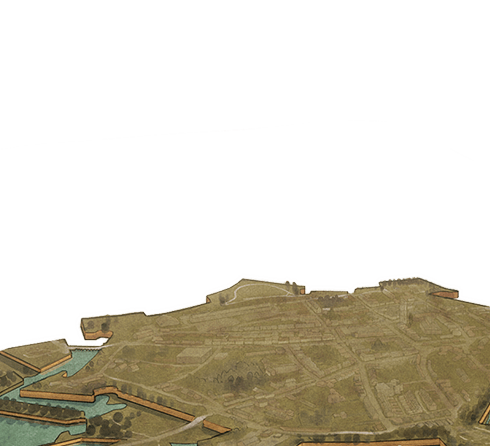
You’re standing on the bank of the Canal du Nord. In front of you are the two bridges over the canal at Havrincourt and the village of Havrincourt itself is further beyond the tree line.

The Canal du Nord in September 1918 was dry, and the canal hadn’t yet been completed, but the walls and what was then, an enormous dry moat, was the real obstacle. The New Zealanders were fighting in this area, and as the Germans evacuated Bapaume, the New Zealanders took Bancourt and Fremicourt. The Canadians were breaking through at Drocourt-Quéant to the north and the Australians were taking Saint Quentin to the South. It’s here that the New Zealanders advance across the canal into the forest of Bois du Havrincourt, that you see on the skyline to your left, and these enormous woods were the next obstacle.

From 2 to 9 September, the New Zealanders gradually fought their way around the edges of that wood, pushing the Germans back. To delay the Allied advance, the Germans destroyed the bridge here. It was then the task of the New Zealand Tunnelling Company, working with engineers, to erect the largest temporary bridge ever constructed by the British Army on the Western Front.

It is a credit to the Tunnellers’ ingenuity that they were selected to carry out what was the most difficult bridging task of the whole war. Its length of 55 metres was regarded as the longest single-span bridge in the history of warfare at that time. This was completed in an amazingly short time frame -– eight days. There was no opportunity for site preparation as it was on the British front line and could not be started before the attack on 27 September. Many of the men that worked on this bridge had worked on the main trunk line in New Zealand - so this was meat and drink to them. It was not until 1926 that this bridge was replaced with a permanent structure.

The New Zealand Tunnellers’ bridge at Havrincourt was a tribute to the work of that Tunnelling Company, but also it reminds us that an army marches on its stomach. As Haig’s armies advanced, following up the German retreat - thousands of tonnes of ammunition, fodder, petrol, supplies and so forth, had to follow them up too. Had the bridge not been built so quickly, then the 3rd Army advance would have ground to a halt, and the Germans would have had plenty of time to consolidate their positions, and fight a more organised, and effective withdrawal.

Russell had trained his division for mobile warfare, and he used his three infantry brigades with artillery, cavalry, and tanks moving up behind his Mounted Rifles who looked for the weak spots in the German line. The key was to keep the ball rolling. Around the edges of Havrincourt Wood, the New Zealanders kept mounting attacks, pushing the Germans back over 13 kilometers, and this pressure, stopped them from mounting a better defence.

Let’s move on to Metz-en-Couture Cemetery.

How to get here

Getting there

From the Gare d’Arras take Boulevard Carnot and turn 1st left on to the D917 following the sign towards Beaurains. Continue on the D917 for approximately 20 kilometres. At the roundabout take the third exit continuing on the D917. At the second roundabout take the second exit to stay on the D917 towards Lille/Autres Directions. At the third roundabout take the third exit onto the D930 signposted to Cambrai. Continue on the D930 for about 10 kilometres. Turn right at the signpost to Hermies/Doignies onto the D34. Continue on the D34 through Doignies. Continue through Hermies as the road changes to the D5.

Continue through Hermies following the D5, which turns left at the T-junction. After about 1.5 kilometres you will come to Havrincourt Bridge. 

Where to stand

Find a park before you cross the bridge and walk back towards the bridge you have just crossed. Stand facing where the bridge begins.

GPS
50°6'36"N
3°4'4"E
Decimal GPS
50.11001
3.0678
  • The New Zealand assault and capture of Le Quesnoy, Battle of the Sambre, 4 November 1918.
    The New Zealand assault and capture of Le Quesnoy, Battle of the Sambre, 4 November 1918.
  • The bridge built over Canal du Nord by the New Zealand tunnellers in 1918.
    The bridge built over Canal du Nord by the New Zealand tunnellers in 1918.Credits

    J.C. Neill (ed), The New Zealand Tunnelling Company 1915-1919, Whitcombe and Tombs, 1922

  • Officers of the New Zealand Tunnelling Company stand on the Canal du Nord bridge near Bapaume, France, October 1918.
    Officers of the New Zealand Tunnelling Company stand on the Canal du Nord bridge near Bapaume, France, October 1918.Credits

    Archives New Zealand, WA10/3 ZMR 6/7/4 https://www.flickr.com/photos/archivesnz/14586452390/

  • A bridge over Nord Canal linking Hermies-Metz-en-Couture Road - destroyed by the Germans as they withdrew.
    A bridge over Nord Canal linking Hermies-Metz-en-Couture Road - destroyed by the Germans as they withdrew.Credits

    © Imperial War Museums (Q 47188)

  • A bridge over the Nord Canal between Hermies and Havrincourt - built by New Zealand engineers. September 1918.
    A bridge over the Nord Canal between Hermies and Havrincourt - built by New Zealand engineers. September 1918.Credits

    © Imperial War Museums (Q 47541)

  • A locomotive crosses a German-built bridge between Hermies and Havrincourt.
    A locomotive crosses a German-built bridge between Hermies and Havrincourt.Credits

    © Imperial War Museums (Q 55289)

Stories & Insights

After the Germans were cleared from the walls, Averill was sent forward to investigate.

'Diggers on the Rhine'. New Zealand soldiers on leave in Cologne, Germany. January 1919.

Stationed in Cologne, New Zealand soldiers acted as occupiers, but got on well with the German inhabitants.

This charcoal-wash picture entitled "Stretcher Party" by George Edmund Butler was displayed in 1952 Exhibition of Official War Paintings by New Zealand Artists.

Even with the war nearly over, and the Germans near exhaustion, casualties still mounted.

Leslie Averill (pointing) at the dedication ceremony for the New Zealand memorial at Le Quesnoy, France, 1923.

After the capture of the town, a special bond was formed, which continues to this day.

Like many soldiers during the final weeks, McKenzie had been anticipating Germany’s surrender.

Before Le Quesnoy fell, Nimmo helped mop up German defenders, with a couple of close calls.

Useful resources for those looking for more information.

A selection of First World War vocabulary and common phrases.

Taking The Road to Le Quesnoy trail

Warning: Traffic can be busy so use caution at all times. 

Get to Havrincourt Bridge (the start of this trail) from Arras

GPS: 50.110010, 3.067800

From the Gare d’Arras take Boulevard Carnot and turn 1st left on to the D917 following the sign towards Beaurains. Continue on the D917 for approximately 20 kilometres. At the roundabout take the third exit continuing on the D917. At the second roundabout take the second exit to stay on the D917 towards Lille/Autres Directions. At the third roundabout take the third exit onto the D930 signposted to Cambrai.

Continue on the D930 for about 10 kilometres. Turn right at the signpost to Hermies/Doignies onto the D34. Continue on the D34 through Doignies. Continue through Hermies as the road changes to the D5. Continue through Hermies following the D5, which turns left at the T-junction. After about 1.5 kilometres you will come to Havrincourt Bridge. 

Your stop

Find a park before you cross the bridge and walk back towards the bridge you have just crossed. Stand facing where the bridge begins.

Get to the trail overview at the New Zealand Memorial Le Quesnoy from Arras

GPS: 50.246191, 3.631948

From the Gare d’Arras take Boulevard Faidherbe towards Cambrai, continuing straight on at the crossroads.  When you reach the intersection/traffic lights follow the sign to turn right towards Cambrai onto the D939/Rue Saint-Michel. After crossing the railway tracks you will come to a roundabout. At the roundabout take the second exit and continue towards Cambrai for approximately 30 kilometres.

Just before Cambrai you will come to a roundabout, take the first exit towards the A2/Cambrai onto the D643. You will pass under the A2 and come to a second roundabout, take the first exit towards the A2/Bruxelles. You will go through a toll booth. Take the right hand fork towards Bruxelles to join the motorway. Continue on the A2 for about 33 kilometres. Take exit 22a towards Maubeuge/Le Quesnoy/Bavay. Continue on the D649 for about 10 kilometres. Take the signposted exit to Laon/Le Quesnoy onto the D934. Continue on the D934 for about 5 kilometres.

You will pass under a railway track and a hospital on your left, at the roundabout take the fourth exit onto the D942 towards the Centre Ville/Porte St Martin. At the next roundabout take the first exit onto the D114 towards Centre Ville/Porte St Martin. As you go through the ramparts, take a right signposted to Monument des Néo-Zélandais. Find a park and follow the signposted walk to the New Zealand Memorial. 

Your stop

Stand and face the New Zealand Memorial.

Plan your time

Allow for 2 to 4 hours to explore the entire The Road to Le Quesnoy trail.

If you’re short of time, simply visit stop 5: New Zealand Memorial for an overview of the entire Road to Le Quesnoy.

Nearby places of interest

While you’re here you can also visit the following places:

Musée de Cambrai
The Cambrai Museum features prehistory to present.

Vertigneul Churchyard – Romeries 
This small cemetery features the graves of 19 men who served with the New Zealand Expeditionary Force. 

Jardin des Souvenirs Le Quesnoy
The Garden of Remembrance is situated near the centre of the Le Quesnoy.

Memorial Park of Bullecourt
The Australian Memorial Park Bullecourt features the statue known as ‘The Digger’.

Location Collection: 
Location Name: 
Road to Le Quesnoy
Lat: 
10.7973782999794
Long: 
-40.642252062500006
Lat Real Location: 
50.246191
Long Real Location: 
3.631948

Take the next trail

The next Ngā Tapuwae trail is Brockenhurst. Proceed to St Nicholas Church.
Link to the first stop

Decimal GPS:
65.02188017973471
-108.28962187499997
Sequence:
1
Decimal GPS:
61.22573429520632
-101.5576450625
Sequence:
2
Decimal GPS:
68.38910634696182
-74.29393290625
Sequence:
3
Decimal GPS:
75.30629972519277
-50.21918915624997
Sequence:
4
Decimal GPS:
64.15802586841806
-1.7293801250000342
Sequence:
5
Decimal GPS:
70.15281214467677
-0.7782849062500645
Sequence:
6

Stop Images

Sequence:
1
Decimal GPS Real Location:
50.11001
3.0678
Sequence:
2
Decimal GPS Real Location:
50.06197
3.076144
Sequence:
3
Decimal GPS Real Location:
50.10447
3.247571
Sequence:
4
Decimal GPS Real Location:
50.24017
3.591846
Sequence:
5
Decimal GPS Real Location:
50.24619
3.631948
Sequence:
6
Decimal GPS Real Location:
50.24718
3.638219