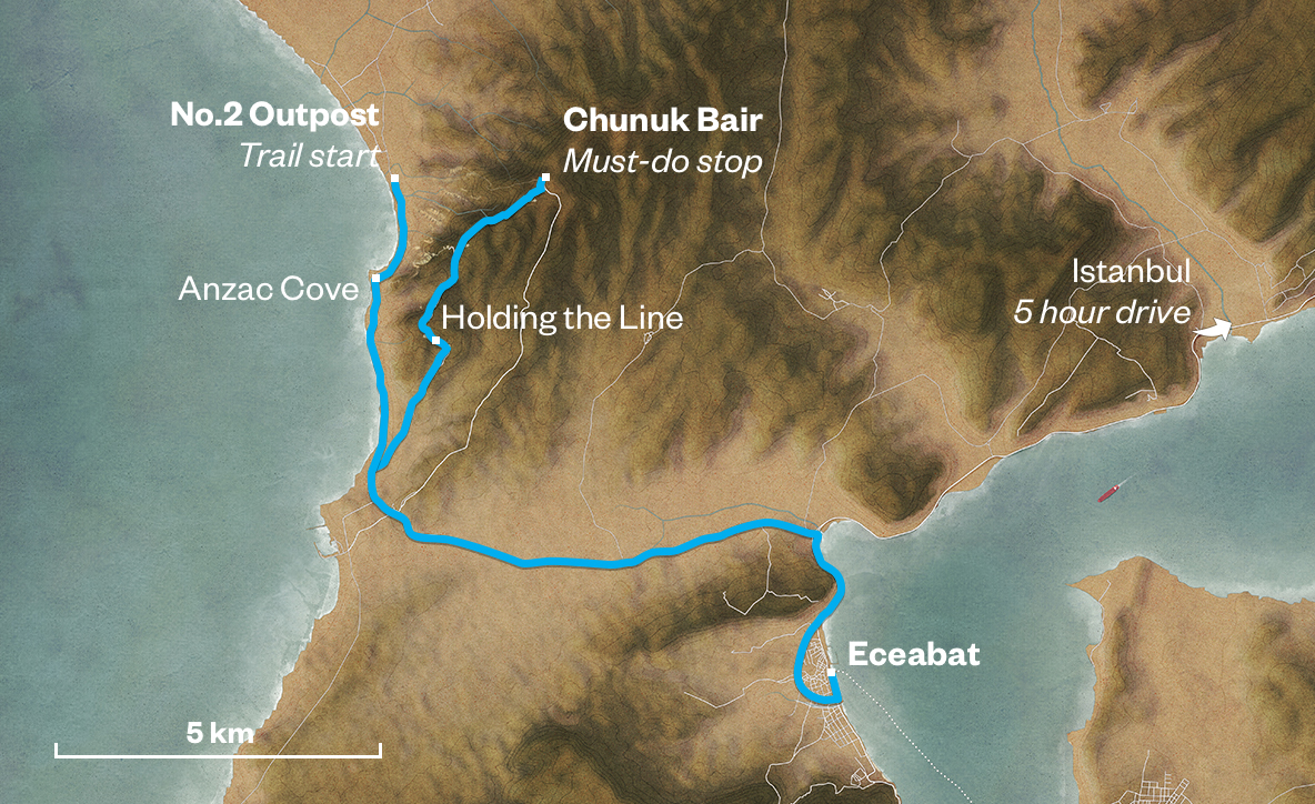
1

No 2 Outpost

No 2 Outpost https://ngatapuwae.govt.nz/gallipoli/chunuk-bair The Anzacs set up outposts along the beach. From these they launched their attack on Chunuk Bair. Ngā Tapuwae Trails /sites/default/files/stop/media/03%20chunuk%20bair%402x.jpg

The Anzacs set up outposts along the beach. From these they launched their attack on Chunuk Bair.

GALL_Zone3_Loc_Number2Outpost_48k24b.mp3
Read this story

No 2 Outpost

You are standing at No 2 Outpost. From here, you can see how far inland the Anzac troops got during the Gallipoli campaign. If you look towards the ocean, you can see the beach running back to the headland, which is Ari Burnu – the northern headland of Anzac Cove. You can see that landscape climbing up to the first major ridge with the clay face on the left, which is Plugge’s Plateau. Then it drops down to a long, straight piece, which is the Razor Edge, then you’ve got the next promontory, which is the Sphinx. If you look along the ridge from which this promontory runs, you can see a clump of pine trees. That’s the Anzac frontline. If you look in the centre of the group of pine trees, you can see the glimmer of a stone memorial.  That is the area of the Nek and that is where Russell’s Top links up with this next slight ridge, which is Baby 700. 

Further down, that cluster of buildings on your right, and to the left of the road, are the headquarters and workshop of the Commonwealth War Graves Commission. They do all the repairs on the cemeteries and memorials here.

No 2 Outpost was one of three outposts established to protect against Ottoman attacks along the beach. If you look to the left of the War Graves Commission building, you can see a small, isolated, bush-covered hill. That is No 1 Outpost. The part below it, where the Native Contingent camped after they landed on the 3rd of July 1915, became known as ‘Maori Pah’. 

The next outpost is No 2 Outpost, where you stand now, and the far north end of this ridge becomes No 3 Outpost. Directly in front of you is Fisherman’s Hut, which was held by the Ottomans on the 25th of April 1915. 

If you look inland, you will see the flat feature that runs off immediately in front of you. In May 1915, Anzac soldiers attempted to expand their hold out here, between this outpost and the high ground. The New Zealanders fought for it and the Turks kicked them off because they were worried that the Anzacs were encroaching into their area in the foothills. That flat feature became known as Old No 3 Outpost. And the Turks strongly fortified that position.

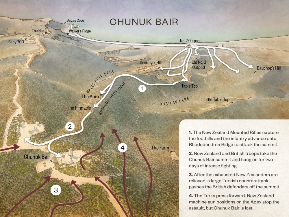
The Outposts became the base for preparing for the August offensive. The objectives included capturing the high ground of the Sari Bair Range: Hill 971, Hill Q and Chunuk Bair. The New Zealand Infantry Brigade were to take Chunuk Bair. Look up to your left to the high ground and look for the flag, and you can see the summit of Chunuk Bair. 

Brigadier-General Andrew Russell, who commanded the New Zealand Mounted Rifles Brigade, took these foothills in front of us.  All four Mounted Rifle regiments were involved: Auckland, Wellington, Canterbury and Otago, the two South island regiments were reinforced by the Native Contingent. 

The Mounted Rifles were going to ‘open the door’ by securing the foothills that dominated the valley, allowing the infantry to advance, and push on towards the summit of Chunuk Bair. 

So, if you can imagine, here on the night of the 6th of August, the men of the Auckland Mounted Rifles already held this position. They waited for the searchlight of HMS Colne to illuminate the ground in front of you. That was followed by artillery fire, and when that stopped, they attacked. It was a silent attack with rifle and bayonet. There was fierce hand-to-hand fighting, in pitch dark with bayonets only. 

By early morning, the Mounted Rifles had cleared these foothills. The door to the high ground was now open, and the next stage was for the Wellington Mounted Rifles to pass through and take the next piece of high ground, called Table Top. If they took this, then the Infantry could come forward and push on up to the ultimate goal - the summit of Chunuk Bair. 

How to get here

Getting there

WARNING: Many locations at Gallipoli are potentially dangerous, and there are undercut cliffs and sudden drops. Go slowly and carefully - and never stand close to a cliff's edge.

From Ari Burnu drive north along the main coastal road till you come to New Zealand No 2 Outpost Cemetery just to the right of the road. Just before the cemetery there is a dirt track leading to No. 2 Outpost Cemetery.

Follow this track inland for about 50 metres, till you come to a smaller trail on the left leading through the scrub. Take this side track, which is the starting point for the New Zealand track leading up to Chunuk Bair.

Where to stand

Follow the track upwards, climbing a dozen or so stairs cut into the earth, til you come to a small saddle with a view of the hills and rugged terrain leading up to Chunuk Bair, site of the New Zealand memorial on the horizon.

Follow the trail to the right, looking out over the Anzac sector. Stand at the southernmost point of No. 2 Outpost.

GPS
40°15'7"N
26°16'59"E
Decimal GPS
40.252
26.28306
  • No 1 Outpost. The covers to the entrances of dugout shelters can be seen along the hillside terraces. Soldiers are lined up in front of the dugouts.
    No 1 Outpost. The covers to the entrances of dugout shelters can be seen along the hillside terraces. Soldiers are lined up in front of the dugouts. Credits

    Read, James Cornelius, 1871-1968. No 1 Outpost, Gallipoli, Turkey. Read, J C :Images of the Gallipoli campaign. Ref: 1/4-058066-F. Alexander Turnbull Library, Wellington, New Zealand. http://natlib.govt.nz/records/23073950

  • It was over this country that the New Zealand infantry advanced during the early hours of the morning.
    It was over this country that the New Zealand infantry advanced during the early hours of the morning.Credits

    Australian War Memorial G01162 http://www.awm.gov.au/collection/G01162/

  • Dugouts at No. 2 Outpost.
    Dugouts at No. 2 Outpost.Credits

    Australian War Memorial J02660 http://www.awm.gov.au/collection/J02660/

  • View of the beach from No 2 Outpost on 12 August 1915.
    View of the beach from No 2 Outpost on 12 August 1915.Credits

    A view of the beach from No 2 Post, Gallipoli, Turkey. Powles family :Photographs. Ref: PA1-o-811-25-2. Alexander Turnbull Library, Wellington, New Zealand.http://natlib.govt.nz/records/23092594

  • Looking South towards Ari Burnu in August 1915
    Looking South towards Ari Burnu in August 1915Credits

    Walkers Ridge, Gallipoli, Turkey, under attack during World War 1. Lawson, Alan Wallace 1893-1961 :Photograph album. Ref: PA1-o-1312-08-1. Alexander Turnbull Library, Wellington, New Zealand. http://natlib.govt.nz/records/22694373

Stories & Insights

Basset braved hails of bullets to lay telephone wires and enable battlefield communications.

Chunuk Bair, the easternmost point reached by the New Zealanders on the 8th August 1915.

After the battle of Chunuk Bair, many Anzac men's bodies were left where they lay - their clothes falling away, their bones drying.

New Zealand troops share a pipe in a dugout at the Signalling Station on No 2 Outpost.

Installing and maintaining telephone and telegraph lines at the front was difficult work, and sometimes deadly.

A maori tiki carved into the rock along the main sap to Fisherman's hut. The sign reads : NZ Maori pah and a carved hand pointing to the left indicating the Maori meeting place is to the left. 1915

Māori soldiers yelled Te Rauparaha's famous 'ka mate' haka through the night, as they advanced on Sari Bair.

Shot through the neck, Carkeek knew the only way to reach an anchored hospital ship was crawl down to the beach.

A photo of the Bivvy shared between 9/803 Corporal Curll Alexander Gordon Catto and 9/337 Trooper William Parlane (pictured), No 2 Outpost, Gallipoli.

Every Anzac soldier was needed for the attack on Sari Bair, no matter how sick or exhausted he was.

As the Turks closed in, Surgenor found himself the last man standing in a shallow trench.

Taking the Chunuk Bair trail

WARNING: Many locations at Gallipoli are potentially dangerous, and there are undercut cliffs and sudden drops. Go slowly and carefully - and never stand close to a cliff's edge.

Get to No 2 Outpost (the start of this trail) from Eceabat

From the ferry wharf in Eceabat, turn left and follow the road along the Dardanelles coast 200 metres before it turns right, looping around the back of the town. Follow this road north for two kms until you reach the roundabout near the coast, signposted for Anzak Koyu (Anzac Cove). Turn left and drive 6kms across the peninsula. This will bring you to the Aegean coast, with the road turning north. Follow the coastal road past Anzac Cove and drive along the coast till you come to New Zealand No 2 Outpost Cemetery to the right of the road. Just before the cemetery there is a dirt track, follow this track inland for about 50 metres, till you come to a smaller trail on the left leading through the scrub. Take this side track, which is the starting point for the New Zealand track leading up to Chunuk Bair. 

Your stop

Follow the track upwards, climbing a dozen or so stairs cut into the earth, till you come to a small saddle with a view of the hills and rugged terrain leading up to Chunuk Bair, site of the New Zealand memorial on the horizon. Follow the trail to the right, looking out over the Anzac sector.   

Get to the must-do stop from Eceabat

From the ferry wharf in Eceabat, turn left and follow the road along the Dardanelles coast 200 metres before it turns right, looping around the back of the town. Follow this road north for 2 kms until you reach the roundabout near the coast, signposted for Anzak Koyu (Anzac Cove). Turn left and drive 6 kms across the peninsula. Take the road signposted for Chunuk Bair (the Conkbayiri road). This road is one-way, though there is the chance you could meet oncoming traffic because some drivers don’t follow these rules. You will pass the Turkish Conkbayiri Mehmet Memorial (five large stone monoliths) on your left. You will reach an intersection, turn left here and you will be able to see the New Zealand battlefield memorial on the summit of Chunuk Bair. 

No car?
Taxi drivers may take you to the main sites, but this can be expensive. You can also hire a private guide. A recommended alternative is pre-booking a bus tour that covers the sites you are interested in visiting. 

Plan your time

Allow 2 hours to explore the entire Chunuk Bair trail. Note that the trail is steep and rugged and requires a degree of fitness and mobility. If you want to go up but not down you can get someone to meet you at the top.

If you’re short of time, you can simply visit the must-do stop on the trail – Chunuk Bair. The audio guide at the summit gives you the big-picture Chunuk Bair story.

Location Collection: 
Location Name: 
Chunuk Bair
Lat: 
40.25183348554802
Long: 
26.282959946899382

Take the next trail

The next Ngā Tapuwae trail is Cape Helles. Proceed to Kilitbahir.
Link to the first stop

Decimal GPS:
70.2781824021454
-18.801583281250032
Sequence:
1
Decimal GPS:
67.08850047908513
-20.669259062500032
Sequence:
2
Decimal GPS:
65.56095822213858
-24.009102812500032
Sequence:
3
Decimal GPS:
62.683967149984994
-57.62726687500009
Sequence:
4
Decimal GPS:
52.47176862422445
-79.29230593750009
Sequence:
5
Decimal GPS:
47.65821020919526
-77.64435671875009
Sequence:
6
Decimal GPS:
45.68384002167691
-80.58869265625009
Sequence:
7

Stop Images

Sequence:
1
Decimal GPS Real Location:
40.252
26.28306
Sequence:
2
Decimal GPS Real Location:
40.25331
26.28891
Sequence:
3
Decimal GPS Real Location:
40.25326
26.29429
Sequence:
4
Decimal GPS Real Location:
40.25175
26.3062
Sequence:
5
Decimal GPS Real Location:
40.25159
26.30762
Sequence:
6
Decimal GPS Real Location:
40.25203
26.30828
Sequence:
7
Decimal GPS Real Location:
40.252
26.30853