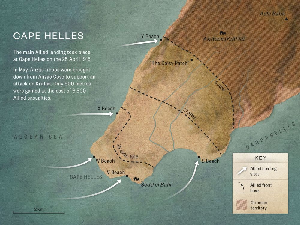
3

V Beach

V Beach https://ngatapuwae.govt.nz/v-beach This is where the first wave of British soldiers landed on the first day of the Gallipoli campaign. The waters ran red with blood. Ngā Tapuwae Trails /sites/default/files/stop/media/04%20cape%20helles%402x.jpg

This is where the first wave of British soldiers landed on the first day of the Gallipoli campaign. The waters ran red with blood.

GALL_Zone4_Loc_VBeach_48k24bit_20150.mp3
Read this story

V Beach

You are standing at the water’s edge on V Beach, and this became the amphitheatre of death for the British soldiers who landed here in broad daylight on 25 April 1915.  

In front of us is the castle of Seddulbair, and you can see the damage done to it by the allied naval bombardment. On the day of the landing, these ruins were held by Turkish Infantry. Next to the castle, on the left, is the village of Seddulbair. On 25 April there were open fields in front of it, and further to the left, on the high ground where the monument now stands, was a Turkish artillery battery – which is marked by the flag. Turkish riflemen occupied all these positions covering the beach.

If you turn to your left you can see, on the headland, the very prominent Memorial, which incorporates the British Memorial to the Missing. Along the ridge overlooking you, were Ottoman defences with riflemen ready to fire down. This is a natural amphitheatre that stretches around, back around through the forward part of the village, to the castle itself. Anything coming down on to this beach would be shot down.

On the morning of 25 April 1915, the British 29th Division landed here in daylight. The centrepiece of the landing was the old transport ship River Clyde, which was converted into a landing ship. Holes had been cut in its sides and ramps erected, so that the British soldiers could run down and stream ashore. This line of rocks where you stand marks the spot where the River Clyde ran aground. It was going to be a simultaneous landing with two infantry battalions carried in boats – but the very strong current meant that the River Clyde arrived first. 

If you can imagine the River Clyde, with barges being towed behind, grounding about 80 metres out from where you stand. The barges were used like a pontoon bridge to form a walkway from ship to shore allowing the infantry to run across and charge inland. In fact, the ship’s captain, Commander Unwin, won a Victoria Cross for jumping into the water under fire and trying to keep the row of barges together. 

There were machine guns mounted on the River Clyde firing at the village and the fort. As the ship grounded, the two side doors opened and men, came racing down the ramps, packed one behind the other while Turkish infantry opened fire and shot them down. 

The Ottoman riflemen fired 15 rounds a minute and soldiers on the River Clyde thought it was machine gun fire. In minutes, each barge between the ship and the shore was crammed with dead and dying men, and anyone who moved was shot by Turkish snipers. Some survivors who got to the beach ran and took cover in that small clay bank by the tree just in front of you – and stayed there for the rest of the day. Any attempt to move was to die. 

A British airman flying a seaplane overhead said that the waters ran red with blood. The British attackers were stuck on this beach for two days before an advance from the next bay across, W Beach, allowed them to clear the village. This beach would become one of the major logistic bases for the British and French armies at Cape Helles, and it was here that the New Zealanders from Anzac Cove landed on 6 May to support the British advance. 

How to get here

Getting there

From the viewing platform continue along the road that has brought you to the viewing platform for 3.7km till you join the road to the Çanakkale Martyrs Memorial. Turn left here onto the two-way road and continue on past the Çanakkale Martyrs Memorial (Çanakkale Sehitleri Aniti). You will come to the central road running south from Alcitepe to Seddülbahir Castle facing you.

Follow the road as it curves right and then turn left again, with the western wall of the castle on your left. The road will lead down to V Beach.

Where to stand

Stand at the water's edge on V Beach. Fae the castle of Seddülbahir, on its left is the village of Seddülbahir.

GPS
40°2'31"N
26°11'7"E
Decimal GPS
40.04212
26.18528
  • The ship `River Clyde' at V Beach, Cape Helles.
    The ship `River Clyde' at V Beach, Cape Helles.Credits

    The ship River Clyde at V Beach, Capes Helles, Gallipoli, Turkey. Field, Arthur Nelson :Lantern slides of Gallipoli. Ref: 1/2-C-010055-F. Alexander Turnbull Library, Wellington, New Zealand. http://natlib.govt.nz/records/22721022

  • Sedd el Bahr from the River Clyde. Some soldiers are sheltering on land, and wounded men are lying on board a lighter in the foreground.
    Sedd el Bahr from the River Clyde. Some soldiers are sheltering on land, and wounded men are lying on board a lighter in the foreground.Credits

    © IWM Q 50473 http://www.iwm.org.uk/collections/item/object/205021950 

  • British landing at V Beach in 1915. Sedd El Bahr Castle is in the background.
    British landing at V Beach in 1915. Sedd El Bahr Castle is in the background.Credits

    British landing at V beach, Gallipoli, Turkey. Gresson, Kenneth MacFarlane, 1891-1974 :Photographs of the Gallipoli campaign in Turkey during World War I, and photographs of ships in a bay. Ref: PAColl-3604-05. Alexander Turnbull Library, Wellington, New Zealand. http://natlib.govt.nz/records/23131158

  • Scene at V Beach with boats, soldiers, horses, supplies and tents. 
    Scene at V Beach with boats, soldiers, horses, supplies and tents. Credits

    V Beach, Cape Helles, Gallipoli, Turkey. Field, Arthur Nelson :Lantern slides of Gallipoli. Ref: 1/2-C-010056-F. Alexander Turnbull Library, Wellington, New Zealand.http://natlib.govt.nz/records/22723832

  • Turkish prisoners captured during the landings at Gallipoli seen in the courtyard of the old fort at Sedd el Bahr
    Turkish prisoners captured during the landings at Gallipoli seen in the courtyard of the old fort at Sedd el BahrCredits

    © IWM Q13226 http://www.iwm.org.uk/collections/item/object/205248463

Stories & Insights

The night before April 25, Freyberg made an epic swim around the coast – lighting flares to distract the Ottomans.

Soldiers graves, Shrapnel Gully

Public anguish and uncertainty grew in New Zealand, as official lists of Gallipoli casualties slowly appeared in newspapers.

British soldiers at Anzac Cove marching along North Beach.

While trans-Tasman relationships warmed at Gallipoli, new tensions emerged between the New Zealanders and the British.

The Bouvet was one of three Allied battleships sunk by mines during the naval attack on the 18th of March 1915

The Gallipoli campaign's land operations are well known, but Allied warships and submarines also played key roles.

Gasparich fought with the Auckland Battalion alongside the British at Krithia – coping with sparse and confusing orders.

Wounded being brought along side an unidentified hospital ship off Gallipoli. A good view of the barges and the lighter towing them. There look to be a number of walking sick and wounded as well as stretcher cases

Gallipoli was - in the end - just a very small part of the First World War story.

Leadley was a qualified telegraphist, so was given a signaller’s role when he enlisted.

Take the next trail

The next Ngā Tapuwae trail is The Defence. Proceed to Hill 60.
Link to the first stop

Decimal GPS:
40.14096
26.37536
Sequence:
1
Decimal GPS:
40.09741254106555
26.25176380859375
Sequence:
2
Decimal GPS:
40.04212
26.18528
Sequence:
3
Decimal GPS:
40.05153
26.16718
Sequence:
4
Decimal GPS:
40.08778
26.2149
Sequence:
5

Stop Images

Sequence:
1
Decimal GPS Real Location:
40.14096
26.37536
Sequence:
2
Decimal GPS Real Location:
40.09699
26.25241
Sequence:
3
Decimal GPS Real Location:
40.04212
26.18528
Sequence:
4
Decimal GPS Real Location:
40.05153
26.16718
Sequence:
5
Decimal GPS Real Location:
40.08778
26.2149